
The stratospheric polar vortex looks to come under attack in the next several days, and possibly beyond, but all indications are that this attack will be weak, and the polar vortex aloft will remain strong.
We'll begin with a current look at the stratosphere.
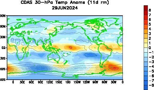
This animation above shows temperature anomalies at the 30-hPa level of the stratosphere, just above the middle part of the stratosphere. Note how over the past month we've seen a few instances of minor warming occurring at 'lower' latitudes, but never reaching a strength adequate enough to be an actual stratospheric warming event. Consequentially, the stratospheric polar vortex has remained pretty much undisturbed. There is some warming commencing over the Himalayan mountain region, and this could incite another minor warming event to spread over the north Pacific, as has happened before in the last 30 days on this animation. Whether it builds into anything substantial remains to be seen, but as the analysis below shows, I'm not optimistic.
The first image we'll analyze is a longitude-by-height chart, forecasted by the ECMWF model for five days' time. This chart is forecasting the presence of a geopotential Wave-1 event in the stratosphere. As the phrase 'Wave-1' indicates, the forecast here is for the risk of a single body of high pressure (hence Wave-1) forming aloft to try and displace the polar vortex. The legend on the left indicates this risk is highest from the 1-millibar to 10-millibar region, where geopotential values are highest and the warm colors are most prominent. This is a pretty strong Wave-1 event, but because it is centered above the 10-millibar level, and it will weaken shortly after this time period five days out, I'm not expecting any long-term damage to the stratospheric polar vortex.
Another tool we can use are time-by-height charts for different levels of the atmosphere to see how much, if any pressure is being applied to the polar vortex. It looks a little intimidating at first, but we'll break it down below.
The top panel shows us the forecast for Wave-1 (explained above) and Wave-2 temperature attacks at the 10-millibar level. The Wave-2 event is where one body or more of high pressure / warm temperatures form aloft (in this case, at the 10-millibar level) and try to split the polar vortex into two vortexes, hence the '2' in Wave-2. Notice the forecast for a Wave-1 event peaking at that 5-day forecast period, which we analyzed above, but then that Wave-2 line starting to rise up towards the end of the forecast period, ten days away. That could be something to monitor, but when we consider Wave-2 events are weaker than Wave-1 events, I'm not particularly encouraged by it.
This description of that top panel also applies to the third panel from the top, except now valid at the 30-millibar level. In this case, however, notice a sustained elevated Wave-1 attack throughout the forecast period, but also a strengthening Wave-2 parameter towards the end of the forecast period. Again, perhaps something to watch, but I'm not exactly keen on it impacting the vortex significantly right now.
Panels 2 and 4 from the top are nearly identical to the first and third panels described above, but these new panels show us Wave-1 and Wave-2 attacks from a geopotential (ridges instead of warm temperatures, although in essence they tend to occur together) standpoint. Note in Panel 2, showing us the forecast at the 10-millibar level, a sustained Wave-1 attack, and a pretty strong one at that, throughout the forecast period. We also see a strengthening Wave-2 event at the end of the forecast period.
The situation in the fourth panel, showing geopotential values at the 30-millibar level, is different than the 10-millibar level. We see a pretty strong Wave-1 event, but a weakening Wave-2 episode. This piques my interest, just because I want to see how that evolves more than anything, and may be something to watch down the road.
To summarize:
- Minor warming has occurred in the stratosphere over the last month, but has had very little impact on the polar vortex.
- Additional minor warming is forecast to occur over the next several days, again with little impact in the lower stratosphere.
- Long-range guidance indicates some items of interest beyond Day 10 forecasts, but I'm personally pessimistic as to the chance of a stratospheric warming event.
- This may keep the chances for a large-scale, significant cold weather event relatively low, speaking strictly from a stratospheric viewpoint.
Andrew
We'll begin with a current look at the stratosphere.
 |
| CPC (Refresh page if animation stops looping) |
 |
| FU-Berlin |
 |
| FU-Berlin |
The top panel shows us the forecast for Wave-1 (explained above) and Wave-2 temperature attacks at the 10-millibar level. The Wave-2 event is where one body or more of high pressure / warm temperatures form aloft (in this case, at the 10-millibar level) and try to split the polar vortex into two vortexes, hence the '2' in Wave-2. Notice the forecast for a Wave-1 event peaking at that 5-day forecast period, which we analyzed above, but then that Wave-2 line starting to rise up towards the end of the forecast period, ten days away. That could be something to monitor, but when we consider Wave-2 events are weaker than Wave-1 events, I'm not particularly encouraged by it.
This description of that top panel also applies to the third panel from the top, except now valid at the 30-millibar level. In this case, however, notice a sustained elevated Wave-1 attack throughout the forecast period, but also a strengthening Wave-2 parameter towards the end of the forecast period. Again, perhaps something to watch, but I'm not exactly keen on it impacting the vortex significantly right now.
Panels 2 and 4 from the top are nearly identical to the first and third panels described above, but these new panels show us Wave-1 and Wave-2 attacks from a geopotential (ridges instead of warm temperatures, although in essence they tend to occur together) standpoint. Note in Panel 2, showing us the forecast at the 10-millibar level, a sustained Wave-1 attack, and a pretty strong one at that, throughout the forecast period. We also see a strengthening Wave-2 event at the end of the forecast period.
The situation in the fourth panel, showing geopotential values at the 30-millibar level, is different than the 10-millibar level. We see a pretty strong Wave-1 event, but a weakening Wave-2 episode. This piques my interest, just because I want to see how that evolves more than anything, and may be something to watch down the road.
To summarize:
- Minor warming has occurred in the stratosphere over the last month, but has had very little impact on the polar vortex.
- Additional minor warming is forecast to occur over the next several days, again with little impact in the lower stratosphere.
- Long-range guidance indicates some items of interest beyond Day 10 forecasts, but I'm personally pessimistic as to the chance of a stratospheric warming event.
- This may keep the chances for a large-scale, significant cold weather event relatively low, speaking strictly from a stratospheric viewpoint.
Andrew


