**This post is dedicated to all those affected by the tragic bombings at the Boston Marathon and the newly-reported JFK Library bombing this afternoon. Our thoughts and prayers go out to the victims.**
The next four days are filled with severe weather potential. Let's break down each day and the cities affected.
Today- April 15th
Storm system is present in Texas this afternoon with associated dry line forming in the western portion of the state. Slight risk of severe weather extends from Texas through Oklahoma and into Missouri. Surface analysis shows a warm front draped along this slight risk area, and it is expected that both this frontal boundary and the incoming storm system will be factors in this evening's severe weather risk. Overall parameters for severe weather support tornado potential in eastern Oklahoma and southern Missouri, with an enhanced damaging wind threat in the same areas.
Tomorrow - April 16th
Model guidance indicates the storm system will continue to churn in the Southern Plains, with the previously mentioned warm front now becoming stationary and draping itself over much of the slight risk area. Expected thunderstorm development will be along this frontal boundary and associated slight risk area. Closer analysis of the slight risk area reveals the risk to be on the low end, meaning this will not be a widespread severe weather event in terms of severity.
Wednesday - April 17th
This is the outbreak day. The Storm Prediction Center has issued a rare moderate risk area for Oklahoma and southeast Kansas. It's not solely the presence of the moderate risk that makes this rare, it's the fact that this moderate risk area was put out two days in advance. The last time we saw a moderate risk area two days out from a severe weather event was last year. I can't put my finger on it, but I believe that the event ended up being a High Risk severe weather event. Predicted analysis for Oklahoma overnight Wednesday shows high tornado parameters and widespread instability across the region. I will be watching model forecasts in coming hours and days, but this event is looking more potent than the last event that never really materialized.
Thursday - April 18th
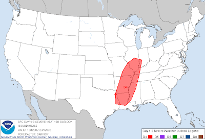
The long range outlook from the Storm Prediction Center has a wide portion of the southern Midwest and Gulf Coast states in a risk area. The SPC doesn't issue specific risk areas for more than two days in advance, they only put out outlines. The associated SPC discussion indicates that this risk will be for a squall line event following Wednesday's event. I will be looking at that event in the future, but my primary focus is on Wednesday's event.
Andrew


