
Thursday, May 3, 2012
Pictures will be posted tomorrow
I am taking shots of the severe weather, and they will be posted tomorrow on my weather photography blog, Vortex Weather Photography.


Cumulus Clouds Bubbling Up
This is a picture that I took a minute ago of a building cumulus cloud. Stay safe everyone!
Severe Thunderstorm Watch #231
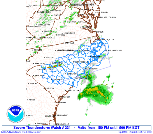
This image is real time.
Discussion
Strong thunderstorms are ongoing just to the north, and this activity appears to be reciprocating to the south, as small but intense cells begin to initiate within the watch box. These storms should quickly feed on high instability, temperatures and dewpoints to keep the severe weather threat continuing through the early evening.
Severe Thunderstorm Watch #230
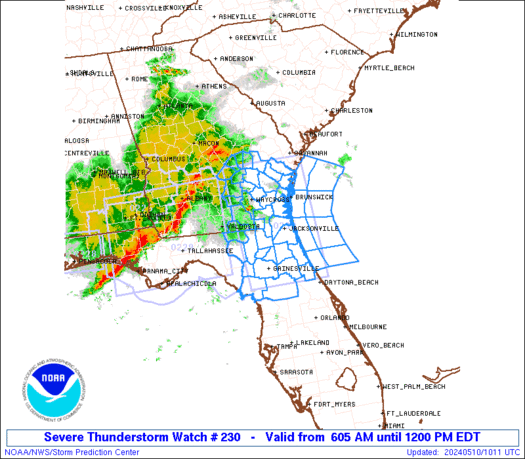
Discussion
A feature currently initiating showers and storms is in the northern part of this watch box. The storms are moving progressively east, onto Lake Michigan. Because storms have now formed in southern Wisconsin, it is possible an outflow boundary has formed and is moving south towards northern Illinois. Should this happen, storms would ignite there as well. However, that is not evident on visible satellite imagery.
GOES Satellite imagery has detected a Lifted Index value of -12 in extreme northeast Illinois, meaning that the atmosphere is very ripe for thunderstorms. More to come.
Severe Thunderstorm Watch #229
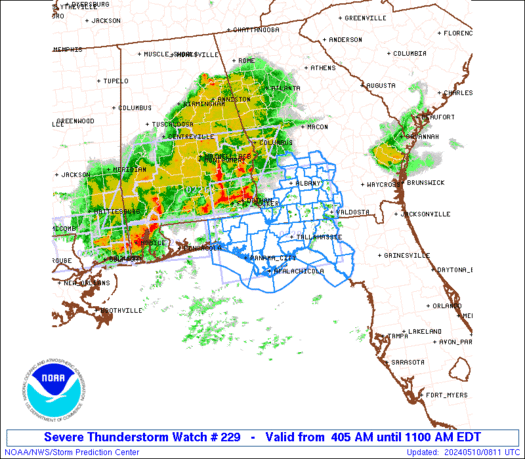
This image is real time.
Discussion
Strong to severe thunderstorms are currently within the watch box. It does appear that a feature is causing these storms, as evident in the storms along a rough line form Michigan into Wisconsin. These storms are within the midst of high dewpoints and instability which will support the storms into the evening hours.
Sunday May Have Fireworks Across the Midwest
.gif)
Andrew
Weekend May Start With a Bang
.gif)
.gif)
There is a risk for severe weather across the Plains, Southeast and Texas.
A severe threat has been ongoing in Texas for a few days now, leading me to believe that this is the result of a stalled frontal boundary. A stalled frontal boundary would indeed lead to an increased tornado threat as a converging wind field would make for some shearing. However, seeing as the jet stream is currently zonal, I would rather not decide on that immediately.
The Plains will be getting in on more severe weather, for at least the 3rd day in a row this Saturday. This time there will be shearing from the lower and mid levels of the atmosphere, so there is indeed a tornado threat as high instability helps along with that potential.
The Southeast will be getting in on some severe weather also, as a trough of low pressure interacts with the environment to make for some low shearing and fairly moderate instability. I am thinking this will be a hail/damaging wind threat for this area.
Severe Weather Threat Hits Plains on Friday
.gif)
.gif) |
| Probability of severe weather |
Andrew
Large Hail, Damaging Wind Threats Dominate Today
.gif) |
| Overall Risk |
.gif) |
| Hail Risk |
.gif) |
| Tornado Risk |
.gif) |
| Damaging Wind Risk |
Storm clusters are ongoing in the midst of fair instability. Some of these storm cells are severe. Forecasts from the WRF are showing that this was indeed predicted, and that model is showing these storms to eventually impact the eastern half of the highlighted area in the Damaging Wind graphic. When they come through, it is looking like these storms won't be extremely severe, but be warned that models can underestimate severe weather, so I will trust the SPC on this one and believe that the storms will live up to the risk.
Subscribe to:
Posts (Atom)