Saturday, January 7, 2012

Re-Evaluation of Winter Coming Out Tomorrow

We are conducting a thorough study into the factors that will influence the rest of winter.
This study will be released tomorrow at 12:00 PM CST.
It will be the final study on this winter.

---

I know you all are upset that winter isn't turning out as expected, but don't shoot the messenger.
For your information, I am pulling my hair out waiting for winter to get going.
I am trying my best to show when the pattern will change- it's the best I can do.
I can do what some people are doing and give up right now, or say that winter will start tomorrow with 5 feet of snow.
But both are ridiculous. I am a moderate, and i'm just trying to convey my truest thoughts. If you're trying to blame someone, blame the atmosphere, because that's the thing that controls what I try to convey.

~Andrew

Signs of More Stratospheric Warming Appearing

We are seeing signs of intense stratospheric warming in the near future per the ECMWF model. Let's break down the images. The first one is the forecasted 10mb temperatures. We can see a sudden spike in atmospheric temperatures around the end of the ECMWF timeframe. The totally dashed line is the 30 year mean of 10mb temperatures. The second image is projected 30mb temperatures. In a similar fashion, we see a big increase in temperatures from where we are now.
This is only one model, but here's the thing- the stratosphere is somewhere around its tipping point. The Sudden Stratospheric Warming event we recently had has done a number on the stratosphere. As of right now, the stratosphere is cooling down, but if this big warming comes to light, we may be seeing the 'Big Warm'- when the stratosphere warms for good to accompany the season changing into winter.
Now, the Big Warm is something that is hard to predict, so don't hold me to this. However, at some point the stratosphere has to break into the winter season, and it's only a matter of time now.
What we have here is a graph projecting temperature waves into the stratosphere. Basically, when the lines are higher up, it indicates a higher amount of warm air being pushed into the stratosphere which would help warm it up. In order to get the stratosphere to warm to the warming that we need to help the pattern change, we ideally want both waves to get into the upper parts of the image. It is encouraging seeing the Wave 2 forecast move higher up on the map.
This is getting more interesting by the day, folks.

Not Convinced An El Nino Will Form This Winter

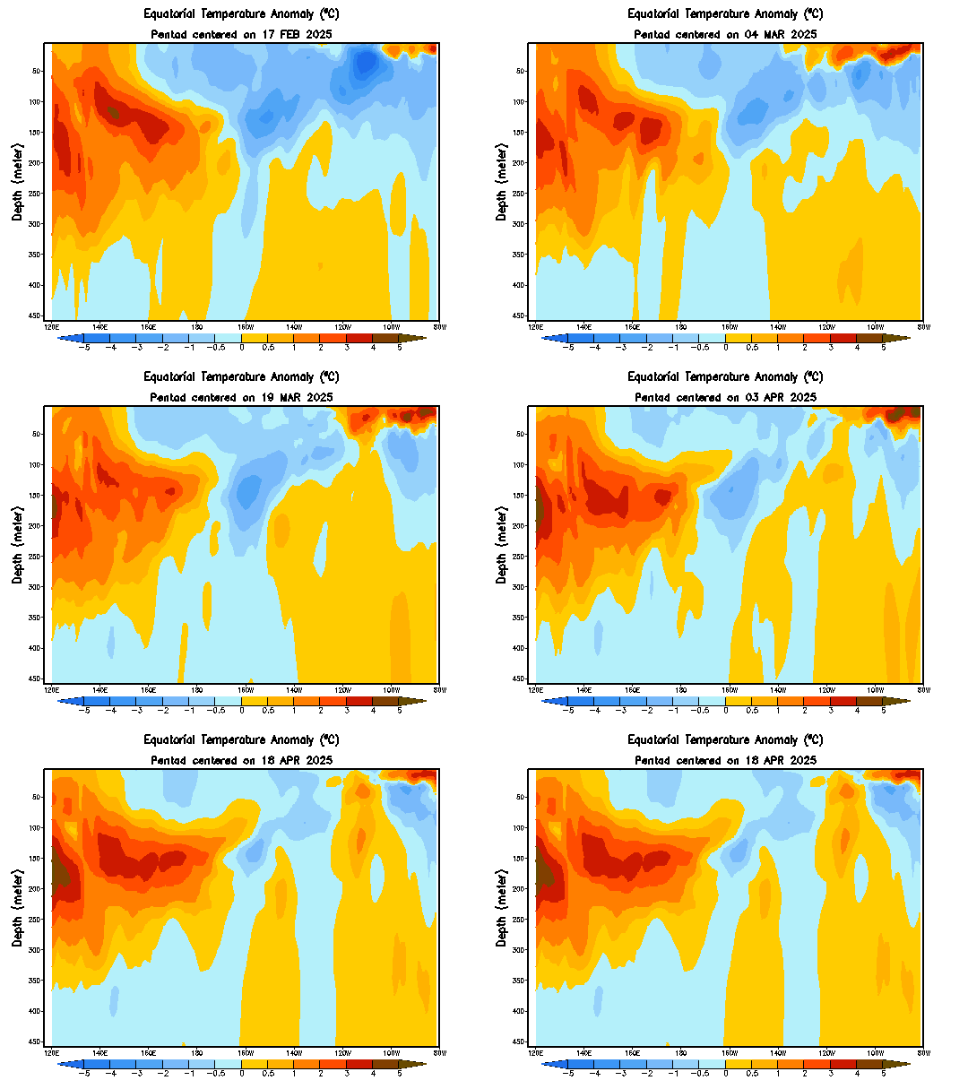
What you see here is the temperature anomalies of the ENSO monitoring areas, where we look for El Ninos or La Ninas. El Ninos involve warmer temperatures, while La Ninas involve cooler temperatures. As you can see we are in a La Nina, with cool temperature anomalies present in the east and central portions of the ENSO monitoring area. We do, however, see some warmer anomalies in the western areas of the ENSO monitoring area. If this was to be more widespread and up at the surface (the top of the screen), it would be an El Nino, which favors snow and cold for the Northeast. However, right now we have the cool sea temperature anomalies spreading westward. After this development, if an El Nino is going to happen, we would see it happen around Late January, with the effects starting in February. Something that cannot be disputed is the SOI, which we covered in a morning post here.

We will have to see, but for right now I cannot see a full blown El Nino taking shape as per ENSO Temperatures, but we will have to keep up to date with the SOI as that is a whole different story.

Ask Questions About This Winter HERE

You may ask any questions you want pertaining to winter on this link in the comments section below.

Questions will be answered from 12-1 PM CST. Questions asked AFTER 1:00 PM CST will not be answered.

We will answer all questions.

You can ask as many questions as you want. If you need some examples, here are a few:
-Personal winter forecasts (they will be brief if you ask for yours).
-AO/NAO/La Nina/El Nino
-Terms you may not understand (i.e. Polar Vortex, AO, NAO)
-Anything else about the winter you can think of!

Ask away!

30 Minutes Until We Open the Winter Questions Link

There are just under 30 minutes until we open the link where you will be able to ask questions on the winter from 12-1 PM CST.

SOI Values Suddenly Collapse


Use the legend at the top for corresponding columns.
In recent days we have seen the SOI values fall apart. The SOI is used to measure La Ninas/El Ninos. When a La Nina is present, the SOI is positive When an El Nino is present, the SOI is negative. This is very interesting, because we appear to be potentially moving into an El Nino, according to the SOI. Considering the winter pattern so far, I can't say i'm surprised, as this winter hasn't exactly been 'winter'.
(For the record, Accuweather Meteorologist Henry Margusity first predicted an El Nino for February a little while back)
What does this sudden change mean? Theoretically, it means we are going into an El Nino. By now, you probably know that when I use the word 'theoretically', it means that it would happen under its own circumstances without any other factors influencing it. However, that's not the way the weather works. We have a pattern change in progress, along with many indices to keep track of, such as the NAO/AO/PNA etc.
I think that this will be a very favorable pattern for at least the Northeast. An El Nino favors the Northeast for precipitation. That, combined with the extremely early-stage pattern change, should make for a cold and snowy winter for the Northeast starting around February into March. The South should continue to get some wet weather as we have been seeing.
Areas like the Great Lakes are a bit harder to forecast. All this cold that may eventually come down would produce some snowy weather for the area. However, an El Nino typically does not favor the Great Lakes, unless there is an East Based -NAO, which could be debatable. It is possible, considering a -NAO will be taking over. It's really confusing in my eyes as there are even more things that will have to be factored in.

Remember, you can ask questions about this winter from 12-1 PM CST today. We will provide a link on this blog where you can post your questions and they will be answered. More info here.

TODAY: Ask Questions About Winter *LIVE* from 12-1 PM CST

You can ask questions about ANYTHING pertaining to this winter from 12:00-1:00 PM (CST).

Some other notes about this:
-You can ask forecasts, a general overview, or even terms you don't understand on this blog!
-The number of questions you ask is unlimited.
-We will make our best efforts to answer every question by 1:00 PM CST. But if there are questions submitted after 1:00 PM CST, we will not be answering them.

We will provide a link at 12:00 PM CST where you can post your questions.
It will be on this blog.