Friday, April 30, 2010

Current risks tonight.


New photos for tonight

[no image]

Excerpt from tonight's Chicago forecast

Strong thunderstorms likely. Storms may produce large hail and strong winds. Low 61F. Winds SSW at 20 to 30 mph. Chance of rain 80%.

UPDATE ON PDS

A squall line currently entering illinois is producing hail, mesocyclones, and winds. You are urged to secure your outdoors belongings by about 6pm

Tornado watch until 8pm CDT


A tornado watch means conditions are favorable for tornadoes

Article from WGN Weather blog

With strong winds surface and aloft, increasing moisture and an approaching cold front all systems are go for severe thunderstorms and possible tornadoes in the Chicago area and the Midwest.

Currently a line of severe thunderstorms is racing northeast from Iowa towards northwest Illinois and southwest Wisconsin at speeds approaching 70 mph. These storms have produced wind damage to trees and powerline in Iowa and dropped hail up to 1 inch in diameter.

Currently these storms pose no threat to Chicago but are targeting areas in northwest Illinois west of Rockford to Dubuque and areas in southwest Wisconsin west of Madison and Janesville to the Mississippi River.

Wind gusts from yesterday


This means high wind shear, which is favorable for tornadoes.
This is probable tonight

Map for midnight tonight


Outlined green area is thunderstorm activity

Current weather maps watches and warnings


The yellow is tornado watch

Rainfall map through Saturday (tomorrow)

Word of the day

Mesocyclone: A rotating column of air in the clouds. Can produce tornadoes.

Current Radar image as of 3:50pm CDT


These storms have produced mesocyclones and are moving strictly northeast

severe map as of 130pm CDT

[no image]

The big threat probably has shifted eastward

SPC Pictures for severe threat


Tornado Watch

Tornado watch over north Illinois

PARTICULARLY DANGEROUS SITUATION

TONIGHT, EVERYONE IN THE MIDWEST IS STRONGLY ADVISED TO BR PREPARED FOR WIDESPREAD AND INTENSE SEVERE WEATHER.

Notice...

There is unstable information that has been gathered for the Chicagoland area. For this reason, no maps will be put up this morning.

Thursday, April 29, 2010

Weather Watch

A WIND ADVISORY is in effect in the Chicagoland area, as well as a SEVERE THUNDERSTORM WARNING in Minnesota, and a TORNADO WATCH in Kansas and Nebraska.

Surface analysis maps for Friday April 30


You can see, from bottom to top, the pictures show the warm front pulling through. The bottom picture is midnight tonight, 2nd picture is 6am tomorrow, top picture is noon tomorrow.

map April 30 Friday

[no image]

Chicago is in fact in this tornado threat due to the closeness of the threats

Severe probability map/threat map for tomorrow, Friday, April 30


Note: Although the severe threat has shifted west, areas slightly east of the new threat such as Chicago, still have a the substantial chance for severe weather.

Photos for weather event tomorrow.


Wednesday, April 28, 2010

April 30 map

High wind shear danger on Friday

High wind shear over Friday will be a big threat for tornadoes. Wind shear is what makes clouds turn and rotate. Be careful with the weather.

Picture gallery for Friday April 30


This picture is noon on Friday. Here, the cold front will induce severe thunderstorms with the humid and unstable air.


This is a midnight Friday picture. The warm front has pulled through, and the cold front will create dangerous severe storms.

Update on severe weather threat.

Here are the possibilities and/or likelihoods of severe weather risks:

rain: Likely
thunderstorms: Likely
Supercells: LIKELY, MONITOR FOR DANGER
Bow-echo storm cluster: LIKELY, MONITOR FOR DANGER
Flooding: Possible
Tornadoes: POSSIBLE, LOOK FOR HIGH WINDS
Hail: Possible

Notice

In the case of a severe weather event, I will be issuing warnings and watches for the Midwest areas this Friday. Stay tuned.

Another Friday Map


These are risks for severe weather categories.

Friday's probability for severe weather


You can see the hatched area (llight blue) is in the Chicagoland/Iowa area. It appears the SPC is declaring organized severe thunderstorms such as squall lines are LIKELY for Friday.

Tuesday, April 27, 2010

Other Map


This is a newer map that was issued at approximetally 4pm Today. This highlights some severe weather potential.

New Rainfall map for the next 5 days


This is not an accurate map I have provided, but it offers SOME insight to the incoming severe threat.

Tornado Aley update


THIS IMAGE IS FROM 2010. ALL INFO BELOW IS FROM 2010.
[no image]


Here is the new threat for the infamous 'Tornado Alley'. It is likely the severe weather season may be slow to start, but history shows the severe weather season comes back with a vengence. I would also like to mention that this displayed Jet stream is very relative to the jet stream the Midwest will experience with its severe storms April 30

April 30 New Map


Note in this new map of the Day 4 analysis (April 30) how the cold front is literally waiting to pounce on our humidity and warmth in Illinois, Missouri, and other states.

Update on storm threat

Forecasts continue to project the warm front pulling through the area, with temperatures expected in the mid 70s. It is probable humidity will follow. The cold front will have to be closely watched as it comes dangerously close to Northern Illinois. As everyone knows, thunderstorms occur AHEAD of cold fronts. We will be ahead of this cold front. With the instability and humidity and warmth, it may create an explosive environment.

Update on Midwest threat

It now appears all of illinois will be coered in Friday's severe weather threat, with the western mississippi valley recieving the storms on thursday. These storems have potential for hail, tornadoes, and wind.

Days 4-5 Possible rain amounts

Monday, April 26, 2010

Estimate on upcoming midwest storms

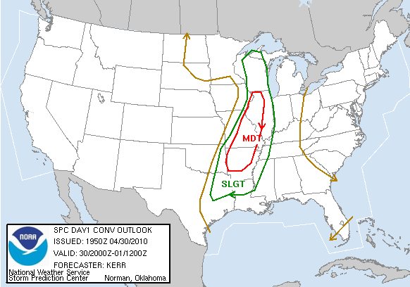
Here is my forecast for the upcoming midwest storm...

After analyzation, it appears that if the moist, unstable, warm Gulf air can be pulled up far enough so that it stands when the cold front comes through, intense severe thunderstorms will develop. A source for the weather has said these severe storms will be happening in the midwest area at some point.

SUMMARY: It has potential to happen. If it happens, it will be intense and severe.

April 30 severe threat


This photo displays a cold front with humid warm air being pulled out of the Gulf of mexico. This air is unstable, which will create potential for severe thunderstorms.


This displays a potent weather system with potent severe weather in the Iowa-Wisconsin-Minnesota area. The cold air will combine with humid warm unstable air to create very strong thunderstorms.

Welcome to the Weather Centre

Here, we monitor the weather for the Midwest area, and any significant severe weather events. Links and photos will be posted here quite often.