Friday, December 31, 2010
Weather Explained: Supercell
What is a supercell?
A supercell is the most likely to become severe. It is isolated from other storms. Supercells are characterized by their rotation in clouds.
What does a supercell look like from the ground?
A supercell is defined by the almost circle-like formation in the clouds.
What does a supercell look like on radar?
Supercells are very well seen, like something is swirling the storm into one spot.
That is the most telltale sign in a supercell. If you see one, find cover immediately.
Are supercells dangerous?
They are the most dangerous of thunderstorms and have most potential to be severe.
Other information
Because the supercell shows a swirl, it is a very strong example of how a tornado forms. If you see that type of swirl, supercell or not, it has the most likely chance of being a tornado.
Weather Explained: Bow Echo
What is a Bow Echo?
A bow echo is a line of storms in a curve shape. Below is a picture.
It is a squall line that carries very intense winds.
What can a bow echo do?
Bow echoes are extremely windy. They are very similar to squall lines. They do have more potential to produce tornadoes, as the winds are higher and there is a curve in the line, which is conductive for tornado formation.
Are bow echoes dangerous?
Yes they are.
What can I do if I see a bow echo coming?
Take anything that can fly away outside inside. Bow echoes can topple trees and are associated with supercells, which will be in the next Weather Explained.
How will I see a bow echo on radar?
You will see a line of intense storms in a big curve.
Plains Blizzard creating Hazardous Conditions.
A low pressure system is currently moving north in the Midwest. It is producing heavy snow and blizzard conditions in the Plains.
The Storm Prediction Center has issued an image on the matter.

Above, we can see the low pressure moving up through Nebraska into Iowa. The green arrow means warm, moist air is moving into the area outlined, making a very nice area for heavy snow. In the pink outline, blizzard conditions are expected, with snowfall rates of 1'' an hour likely. And in the blue area, 2'' an hour of snow is possible. That is incredibly fast accumulation.
Below is an image from the Weather Channel.

The heaviest rain will fall in the Southeast back into the Northeast US. The most snow will occur in the Upper Midwest through the Upper Plains. The worst-hit areas can expect 6-12'' of snow, with localized higher amounts.
Updates as they come, here, at The Weather Centre.
Weather Explained: Squall Line
What is a squall line?
A squall line is a band of intense storms moving together in a line. They are associated with cold fronts, as cold air meets warm air.
What do squall lines do?
Tornadoes have been known to occur more often in single-celled storms. Squall lines are like a big line of single-celled storms. Squall lines are very likely to produce high winds, because they move so quickly and can be in a bow echo, which will be in the next Weather Explained.
Are squall lines dangerous?
Yes. They are very dangerous at times.
What do squall lines look like?
On a radar, they come up as a line of storms. Below is an image of a squall line.
You can see the leading edge of storms at the front, where the cold air first meets the warm air. Then, the cold air overtakes the warm air, and the storms die down after the first line of storms.
Severe storms strike Midwest, Plains.
Severe storms are currently hitting the Midwest and exiting the Plains. The storms are the result of a low pressure system moving north through the Plains with a cold front, bringing an end to the warm weather across the east US.
Multiple watches are in effect at this time, and reports of tornadoes, wind and hail have come in.
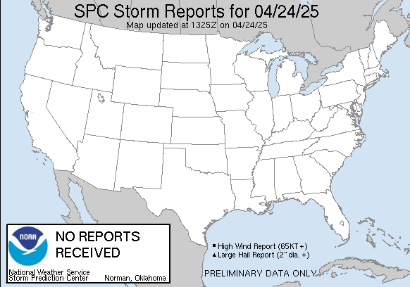
The below image is a report status.

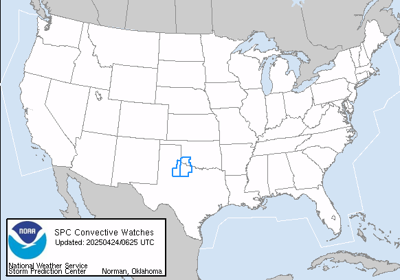
As we can see, the storm really took off on the Missouri-Illinois storms, bringing most of the tornado reports in. The storms even extended into Oklahoma at one point. Below is an image of current watches in the US.

The red boxes are tornado watches. So, the south is getting hit, back through the Midwest nearing Chicago. They are in a squall line formation.
More information as it comes in.
Thursday, December 30, 2010
National New Years Forecast
Good evening everyone!
It looks like it's almost time to ring in the new year, and that means it's time for your New Years forecast!
Out in the Northwest, not much will be happening. A trough, or area of continuous low pressure, will be in the far east reaches of the Northwest. However, it will be mainly in Canada as it moves away from the Northwest. A low pressure system will be offshore, but it looks like the precipitation will stay away from the region. Clouds are likely.
Down into the Southwest, high pressure will be in the area, keeping the region high and dry. While clouds are likely by the Pacific Ocean shore from a low pressure system offshore, most areas farther east in the region will be cloudless.
For the general Southern US, a cold front will be over Oklahoma, with another one in south Texas into the Gulf. Precipitation will be associated with these fronts. However, cities such as Dallas, Austin should have variably cloudy skies for the New Year. Tossups for rain and storms are in Houston Texas and Little Rock, Arkansas as the cold front will be somewhat close to the cities around midnight. New Orleans will be dealing with rain and storms as the front moves through, likely canceling firework displays. Mississippi will be covered, extending through west Tennessee and west Kentucky. For the Southeast, high pressure well offshore will keep coastal communities the least cloudy, with areas close to Mississippi in clouds.
In the Northeast, spotty sprinkles of rain are expected in the north portion of New York. The rest of the Northeast will also be affected by the offshore high pressure, again keeping coastal towns' skies as nice as they'll be.
The real mess happens in the Midwest. Countless celebrations will be rained on or snowed on. The dividing line is the Iowa-Illinois border, Missouri-Illinois border, Arkansas-Tennessee border. Areas west will be snowed in, areas east will be under a hard rain with embedded storms. Cities such as Chicago IL, Quad Cities IA, Minneapolis MN, Madison WI will all be affected in one way or another. However. People in IOWA and EAST NEBRASKA may be able to succeed. The dry slot (see Weather Explained) will likely be in that area.
So, in a summary, the Midwest will be a total mess, the Southcentral as well. Southwest and east may be cloudy. Northeast will be fine, as will be Northwest.
Happy New Years!
Wednesday, December 29, 2010
Weather Explained: Dry Slot
What is a dry slot?
A dry slot is an area very close to the centre of a low pressure system where no precipitation occurs. Sometimes, clear skies occur in a dry slot.
Does it happen often?
While there are likely some exceptions, most typical low pressures have dry slots.
Do you have to be in a certain spot to get a dry slot?
Mostly, the dry slot occurs in the general south area extending west.
Can precipitation occur in a dry slot?
There is no moisture to create rain or snow or any precipitation. While sprinkles may find their way in, they are short-lived
Winter Storm barrels through U.S.

The pink are winter storm warnings, which we can see extending from the Upper Plains, covering basically the entire Rocky Mountains. The storm is a very intense storm.

Above is the infrared imagery on the storm. The storm stretches from Mexico well into Canada.
Typically, people in the Midwest would be worried about this storm. But the jet stream will take a sharp dive and set up a pattern bringing the storm up into the Plains instead.
The major snowstorm would set up in the Northwest into the Upper Rockies with light snow extending into much of the Rockies through the Northwest and Canada.

Above is the current GFS forecast track for the New Years storm. The heaviest snow would occur to the west of this system, with heavy rain to the east.
Notice
My apologies for the absence. But even we weatherfolk must take a break sooner or later. New images will be coming out. The Nor' Easter Page is now closed.
Saturday, December 25, 2010
Nor'Easter 12/25 Part 3

Nor'Easter 12/25 Part 1
The Nor'Easter WILL happen. First is the Probability for 4, 8, 12 inches of snow for today.


Merry Christmas!
Merry Christmas everyone! Due to the fact that it is Christmas, The Weather Centre will not be posting new posts today.
Have a happy holiday!
(Snow can be expected in the Ohio Valley down into the Southeast today. Lake effect snow will ignite in Chicago.)
Friday, December 24, 2010
Morning Christmas Storm & Potential Nor'Easter SnowCAST
Images belong to their respective associations.
Christmas Eve Analysis
Merry Christmas Eve, everyone! So, it looks like things are working out the way they should.
Snow is widespread from North Illinois back into Iowa. Chicago and Milwaukee should be receiving snow soon, while Rockford, IL is likely having quite heavy snow.
For later tonight, the snow should continue and exit. Lake effect snow will take control in Chicago for a short period, while lingering flurries are expected across North Illinois as the system moves out.
Below, we have an infrared image of the precip moving through the Midwest.

Radar below displays the heaviest snows.

Thursday, December 23, 2010
Christmas Nor'Easter Update 12/23
Right now, it's looking like the Nor'Easter will NOT happen. But remember: it's still a ways away. Things will change, and you can find out all about the Nor'Easter here at The Weather Centre.
Christmas Storm December 23 Analysis
Right now, general consensus is that precip area of about 4-6'' will occur in Central IL back into Iowa and skimming Missouri and Minnesota. Banding of snow is occurring in Central IL, with snowfall rates increasing , thus decreasing visibility.
Back south, models have set track so storm will move through N. Gulf of Mexico. Precip hotspots look to be East Texas through South Louisiana, then tapering off.
Trouble arises w/ potential nor'easter situation.
General thinking ATTM is storm missing Upper Northeast and moving out to sea. Will have to watch closely.
Winter Weather Advisories Up

Potential Nor'Easter Update
The models are bringing it together that the storm may not happen.
The NAM disagrees, as does the CMC.
However, the GFS likes the Nor'Easter idea.
Wednesday, December 22, 2010
SNOWCAST
A much better quality, all-over better SnowCAST layout will be featured tomorrow if possible.
New Year's MW Storm Forecast precip (GFS)

It does seem a lot, and we're going to see if it's going to be rain.
On ensembles, it looks like this ought to be a rain event. But it's into next year. So don't invest any confidence in this yet.
Subscribe to:
Posts (Atom)


